List of Australian Capital Territory Postcodes Complete
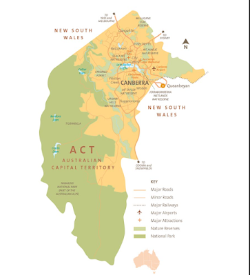
A federal territory of Australia, the Australian Capital Territory (ACT) was formerly known as the Federal Capital Territory (FCT) until 1938. This region is home to Canberra, Australia's capital city. It is situated entirely inside the state of New South Wales in the southeast of the Australian mainland. All significant institutions of the Australian Government have their headquarters in the territory, which was established after Federation as the new country's seat of government.
In Australia, the Australian Capital Territory (ACT) is a territory located in the southeast of the country and serves as the seat of the federal government. Like other regions in Australia, the ACT utilizes a postcode system to facilitate efficient mail sorting and delivery.
Postcodes in the Australian Capital Territory consist of four numerical digits. These digits are used to identify specific geographic areas, suburbs, towns, or districts within the territory. For example, the postcode for Canberra, the capital city of Australia and located within the ACT, is often represented as "2600".
Each postcode in the Australian Capital Territory represents a specific locality or area, allowing mail to be sorted and delivered accurately. Postcodes can cover a small area, such as a single suburb, or a larger area that encompasses multiple suburbs or districts.
Postcodes in the Australian Capital Territory are widely used for addressing purposes, including sending and receiving mail, packages, and other correspondence. They play a vital role in the postal system, ensuring that mail is directed to the correct location within the territory.
The Australian Capital Territory primarily consists of the city of Canberra and its surrounding suburbs. The postcode system helps to differentiate and organize the various suburbs and districts within the ACT, making mail delivery more efficient.
To obtain the correct postcode for a specific address in the Australian Capital Territory, it is recommended to consult an official postcode directory or use online postcode lookup tools provided by Australia Post, the national postal service. These resources allow individuals and businesses to identify the correct postcode for their intended destination within the ACT.
The postcode system in the Australian Capital Territory, as well as the rest of Australia, is essential for ensuring accurate and timely mail delivery. It supports communication, enables e-commerce, and ensures the smooth operation of postal services within the territory.
All postcodes in Australian
Capital Territory
- 0200
- Administrative
Postcode Only
- 0221
- Barton
- 2600
- Barton
- Canberra
- Capital Hill
- Deakin
- Duntroon
- Fairbairn Raaf
- Harman
- Hmas Harman
- Parkes
- Parliament House
- Russell
- Russell Hill
- Yarralumla
- 2601
- Acton
- Black Mountain
- Canberra
- City
- 2602
- Ainslie
- Dickson
- Downer
- Hackett
- Lyneham
- O'connor
- Watson
- 2603
- Forrest
- Griffith
- Manuka
- Red Hill
- 2604
- Causeway
- Kingston
- Narrabundah
- 2605
- Curtin
- Garran
- Hughes
- 2606
- Chifley
- Lyons
- O'malley
- Phillip
- Swinger Hill
- Woden
- 2607
- Farrer
- Isaacs
- Mawson
- Pearce
- Torrens
- 2608
- Administrative
Postcode Only
- 2609
- Canberra International
Airport
- Fyshwick
- Pialligo
- Symonston
- 2610
- Canberra Mc
- 2611
- Brindabella
- Chapman
- Duffy
- Fisher
- Holder
- Mount Stromlo
- Pierces Creek
- Rivett
- Stirling
- Uriarra
- Uriarra
- Uriarra Forest
- Waramanga
- Weston
- Weston Creek
- 2612
- Braddon
- Campbell
- Reid
- Turner
- 2614
- Aranda
- Cook
- Hawker
- Jamison Centre
- Macquarie
- Page
- Scullin
- Weetangera
- 2615
- Charnwood
- Dunlop
- Florey
- Flynn
- Fraser
- Higgins
- Holt
- Kippax
- Kippax Centre
- Latham
- Macgregor
- Melba
- Spence
- 2616
- Belconnen
- 2617
- Belconnen
- Belconnen Dc
- Bruce
- Evatt
- Giralang
- Kaleen
- Lawson
- Mckellar
- 2900
- Greenway
- Tuggeranong
- 2901
- Administrative
Postcode Only
- 2902
- Kambah
- 2903
- Erindale Centre
- Oxley
- Wanniassa
- 2904
- Fadden
- Gowrie
- Macarthur
- Monash
- 2905
- Bonython
- Calwell
- Chisholm
- Gilmore
- Isabella Plains
- Richardson
- Theodore
- 2906
- Banks
- Conder
- Gordon
- 2911
- Crace
- Mitchell
- 2912
- Administrative
Postcode Only
- 2913
- Franklin
- Ginninderra Village
- Ngunnawal
- Nicholls
- Palmerston
- 2914
- Amaroo
- Bonner
- Forde
- Harrison
Australian Capital Territory Maps

